1
 →
→
An agent skill that finds where a photo was taken — OpenStreetMap geometry, elevation skylines, satellite imagery and street view — and shows its work.
Oldcircle/geo-sleuth is an open-source project on GitHub, mainly written in Python. An agent skill that finds where a photo was taken — OpenStreetMap geometry, elevation skylines, satellite imagery and street view — and shows its work. It currently holds 176 stars and 16 forks with 0 open issues, and was last pushed on an unknown date (repository created unknown).
AI Homed tracks it on the Today's Trending board, currently at rank #83 with 0 new stars today.
An agent skill that finds where a photo was taken — and shows its work.




Works with
…and any other agent that reads SKILL.md and runs shell commands.
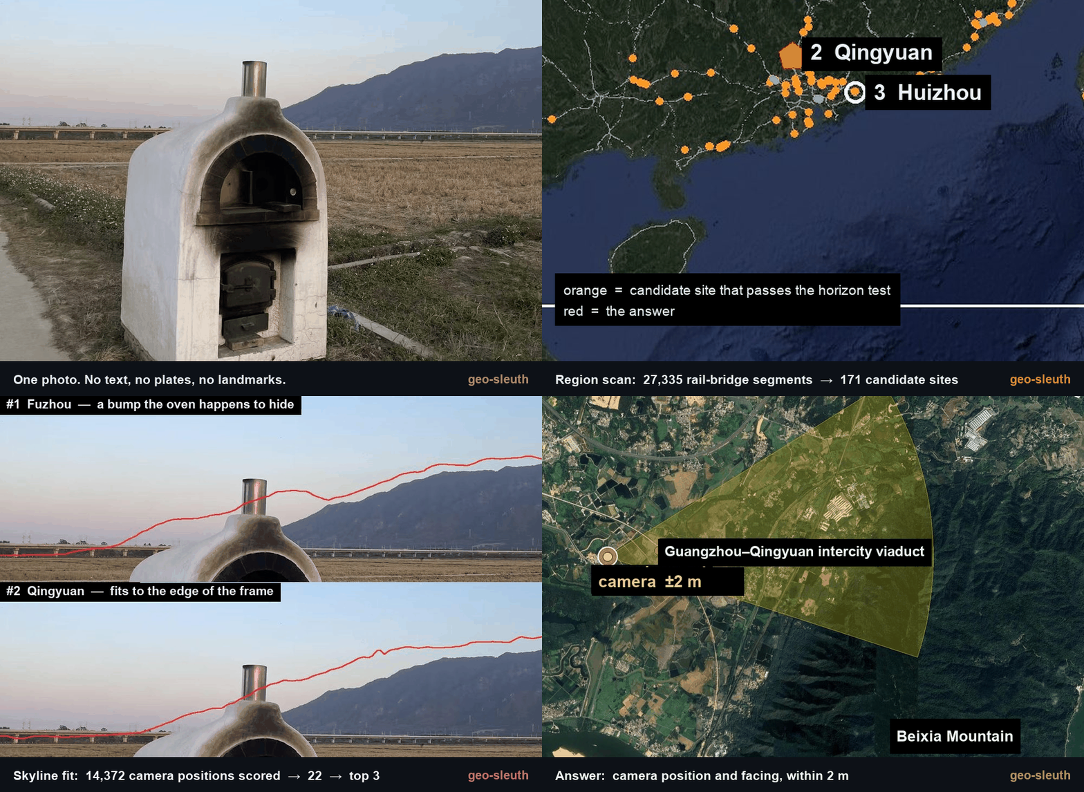
No text. No plates. No landmarks. One bridge, one mountain. Located to within 2 m.
---
npx skills add Oldcircle/geo-sleuth
Pick your agents when prompted. Then hand your agent a photo and say:
find where this photo was taken
That is the whole interface. The agent reads SKILL.md, runs the scripts, and comes back with the camera position, the direction it was facing and a satellite evidence image. Prefer to copy the folder yourself? See Installation.
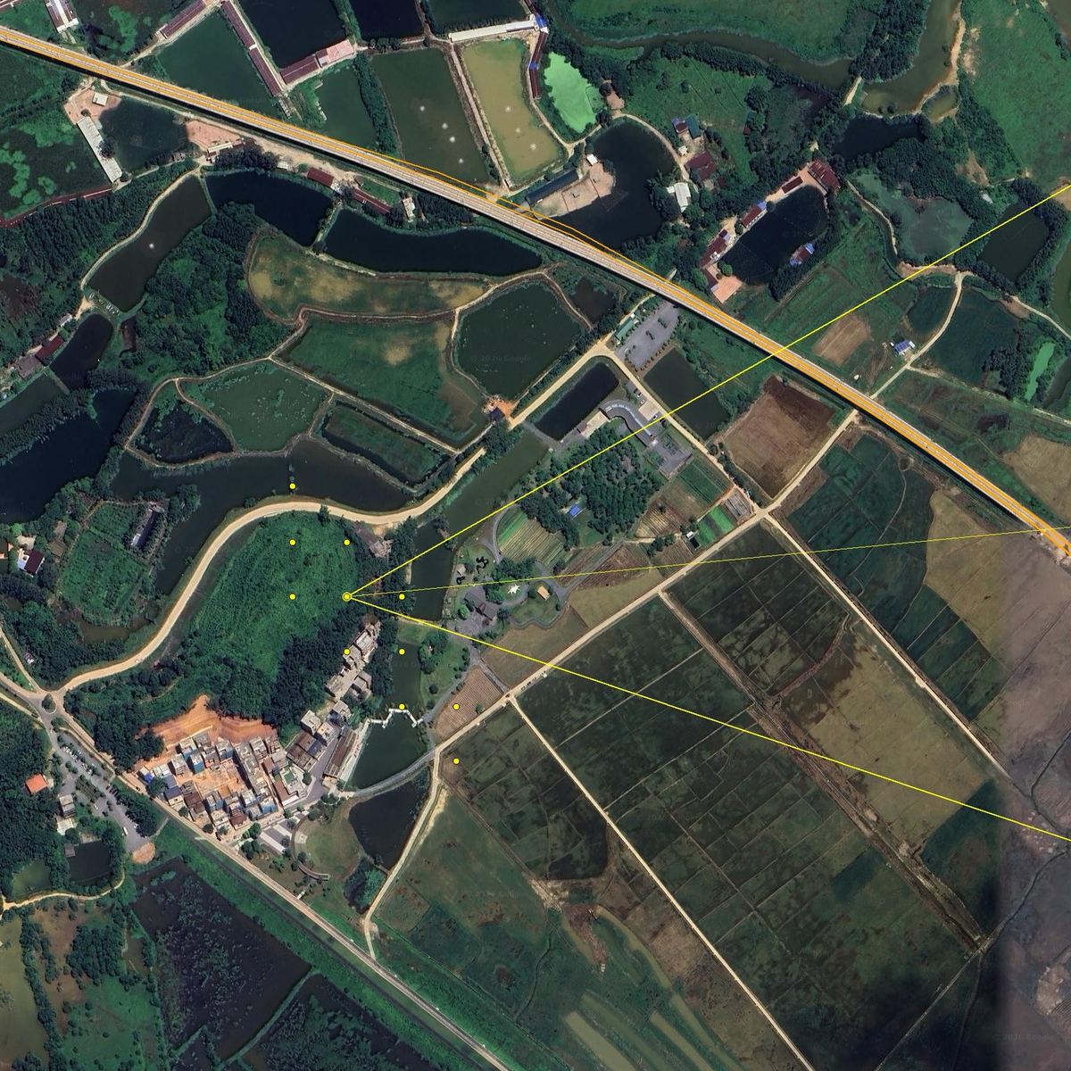
SKILL.md plus plain Python scripts — so the same folder runs in Claude Code, Codex, Cursor, Gemini CLI, OpenCode and GitHub Copilot.A phone photo with the EXIF stripped: a white oven at the edge of a harvested rice paddy, a long viaduct in the distance, a steep mountain on the right. Not a single character in the frame. One message to an agent with this skill installed, and it came back with the camera position and the direction the camera was facing.
photo → 27,335 → 171 → 14,372 → 22 → 3 → 1 → ±2 m
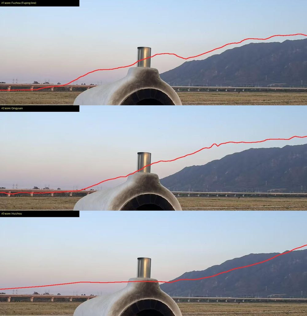
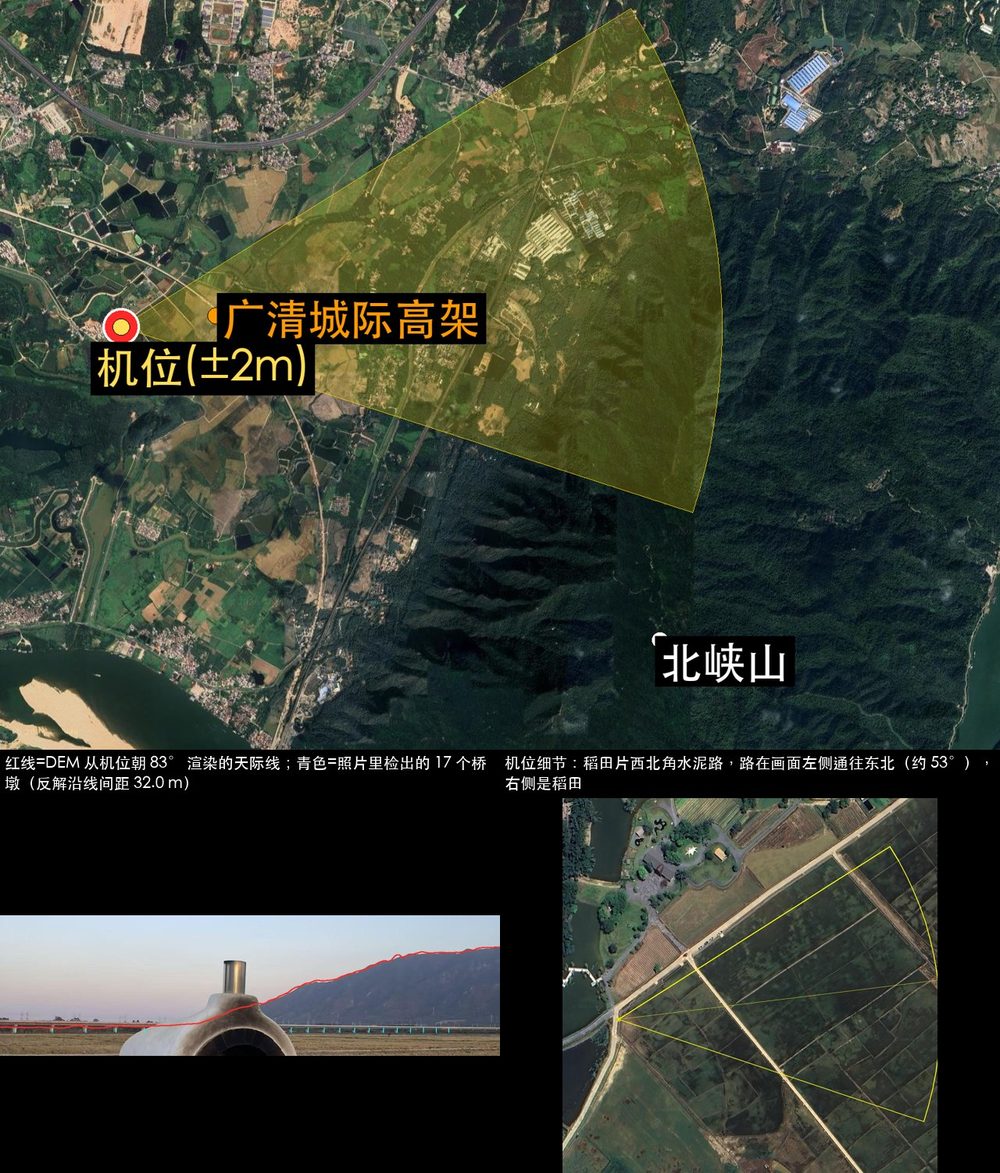
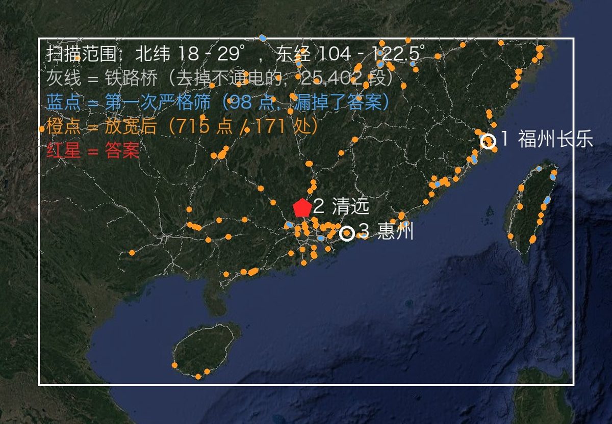
| Step | What it did | Candidates left | |---|---|---| | Read the photo | Poles on the viaduct are catenary masts, so it is an electrified railway. Pier spacing used as a ruler (32 m span assumed): the left segment is about 0.5 km away, the right one over 1 km. A steep mountain about 3 km away. Rice harvested but grass still green, so no frost yet. | South China, as a bet, not a proof | | Region scan | Pulled every railway bridge in the region from OpenStreetMap: 27,335 segments. Sampled a point every 400 m and computed the 360° horizon from elevation data at each one. Kept points with flat ground nearby, a clear mountain within a few km, and a flat horizon next to it. | 171 sites | | Skyline fit | Placed candidate camera positions around each site and rendered the ridge line seen from each one: 14,372 positions. The top 20 were within 0.1° of each other, so it added a constraint: the bridge must be near on the left and far on the right. | 22 | | Overlay check | Drew the top three ridge lines back onto the photo. Score #1 (Fuzhou) had a bump hidden behind the oven, which is why it scored well. #3 (Huizhou) sloped where the photo is flat. #2 (Qingyuan) fit from the foot of the mountain to the edge of the frame. | 1 | | Pier count | 17 piers in the photo become 17 bearings from the camera. Where they hit the railway line, the intersections must be evenly spaced. Combined with the skyline: first a band about 300 m long, then a single spot. | ±2 m |

geo-sleuth is a standard Agent Skill: one folder holding SKILL.md, scripts/, references/ and data/. Install it with the skills CLI, or copy the folder yourself.
All six agents, user-wide, one command:
npx skills add Oldcircle/geo-sleuth -g -a claude-code -a codex -a cursor -a gemini-cli -a opencode -a github-copilot -y
By hand:
git clone https://github.com/Oldcircle/geo-sleuth
mkdir -p ~/.agents/skills ~/.claude/skills
cp -r geo-sleuth/skills/geo-sleuth ~/.agents/skills/              # Codex, Cursor, Gemini CLI, OpenCode, GitHub Copilot
ln -s ~/.agents/skills/geo-sleuth ~/.claude/skills/geo-sleuth     # Claude Code
~/.agents/skills/ is read by Codex, Cursor, Gemini CLI, OpenCode and GitHub Copilot, so one copy there covers all five. Each agent's own folders, from its docs:
| Agent | User-wide | Per project |
|---|---|---|
| Claude Code | ~/.claude/skills/ | .claude/skills/ |
| Codex | ~/.agents/skills/ | .agents/skills/ |
| Cursor | ~/.cursor/skills/ or ~/.agents/skills/ | .cursor/skills/ or .agents/skills/ |
| Gemini CLI | ~/.gemini/skills/ or ~/.agents/skills/ | .gemini/skills/ or .agents/skills/ |
| OpenCode | ~/.config/opencode/skills/ or ~/.agents/skills/ | .opencode/skills/ or .agents/skills/ |
| GitHub Copilot | ~/.copilot/skills/ or ~/.agents/skills/ | .github/skills/ or .agents/skills/ |
Any other agent that reads SKILL.md and runs shell commands works the same way: put the folder where it looks for skills.
The work is split into three layers. Scripts decide, scripts perceive and rank, the model only judges among the top few.
flowchart LR
  A["photo"] --> B["intake.py
EXIF · OCR · reverse image search"]
  B --> C["board.py
candidate board: clues, likelihood ratios, ranking, next step"]
  C --> D{"which branch?"}
  D --> E["sun.py · terrain.py · osm.py · pose.py
shadows, skylines, OSM corridors, camera pose"]
  D --> F["sat_scan.py · match.py · gsv.py · baidu_pano.py
CLIP-ranked satellite tiles, DINOv2+SIFT street view"]
  E --> G["board.py check · report"]
  F --> G
  G --> H["evidence.py
coordinates ± radius · evidence image · graded confidence"]
| Layer | Who | Tools |
|---|---|---|
| Decide: which candidates, how evidence scores, what can be excluded, where to scan next | scripts (the candidate board) | board.py |
| Perceive: read text, look up tables, find targets in satellite tiles, compare street view | scripts rank first, a person looks at the top few | intake.py ocr.py clues.py sat_scan.py match.py geo.py |
| Judge: pull clues from the frame, propose hypotheses, pick among the ranked few | the model | SKILL.md + references/ |
Every conclusion has to point at a command that actually ran in the session and the file it produced. Exclusions need read or computed evidence; observations and guesses can only lower a candidate's weight.
Twenty scripts, one job each. The full table with data sources is in skills/geo-sleuth/references/data-sources.md.
| What it does | Script |
|---|---|
| EXIF: GPS, capture time, equivalent focal length, heading | exif.py |
| OCR on the whole image, zoomed crops and tiles (Apple Vision on macOS, RapidOCR elsewhere) | ocr.py |
| Reverse image search on Baidu and Yandex, similar images tiled into a numbered sheet; keyword image search | revimg.py |
| Steps 0–3 in one command: metadata, edge crops, variants, OCR, reverse search → intake.md | intake.py |
| Zoom crops, edge and corner crops, tiling, pixel columns of evenly spaced structures such as piers | imgprep.py |
| Lookup tables: plate prefixes, landline area codes, calling codes, driving side, dependent territories, administrative divisions | clues.py + data/ |
| Candidate board: candidates, clues, likelihood ratios, exclusion, ranking, scan order, pre-report checks | board.py |
| Gazetteer: list sub-divisions with bounding boxes, built-up area extent | gazetteer.py |
| Place, compound or shop name → coordinate candidates, every namesake listed | poi.py |
| Sun and shadows: latitude band, time of day, street orientation, heading from lit faces, true bearings | sun.py |
| OSM Overpass: feature co-occurrence, line-to-point, route corridors, line intersections, street grid templates | osm.py |
| Satellite tile mosaics, markers, numbered thumbnail sheets | tiles.py |
| CLIP zero-shot scoring of satellite grid cells or candidate points (tracks, factories, silos, dams…) | sat_scan.py |
| Baidu panoramas / Google Street View: find points, render headings, thumbnail sheets, historical batches | baidu_pano.py gsv.py |
| Rank candidate ground-level images against the photo: DINOv2 global similarity + SIFT inliers | match.py |
| Elevation: synthetic mountain views, skyline overlays, profiles; linear feature × terrain scan, ridge extraction, batch skyline scoring | terrain.py |
| Multi-point camera pose: lat/lon, height, heading, pitch, roll, with error radius | pose.py |
| Bearings, distances, line-of-sight intersections, alignment lines, frame/occlusion checks, camera position from evenly spaced structures | geo.py |
| Evidence image: satellite tile + camera fan + comparison grid | evidence.py |
The three steps from the case above (region scan, batch skyline scoring, camera position from pier spacing) are built into the skill as subcommands: terrain.py scan / ridge / fit, imgprep.py piers, geo.py spacing. Case scripts tuned to that photo are kept in examples/rail-skyline-session/ for reference.
Per-operator measurements:
| Script | Test | Result |
|---|---|---|
| match.py | 8 cases: a historical Baidu panorama batch rendered as the photo, panoramas within 150 m as candidates (Shenzhen) | ground truth ranked 1/2/4/1/1 and 5/1/6, all in the top 6, half at #1 |
| sat_scan.py | 4×8 km, 364 cells at z17, 40 OSM-tagged running tracks as ground truth, multi-scale (Shenzhen) | recall@20 17/40, @30 22/40, @100 32/40, median rank 23 |
| terrain.py scan / fit + geo.py spacing | bounded re-run on the case photo above | true cluster ranks #1, final position about 2 m from ground truth |
| clues.py | 6 tables, 9 values spot-checked | 9/9 correct |
The method comes from breaking down 14 videos by online-geolocation creators, 22 puzzles and a set of real runs, then turning what works into rules and scripts. v2 moves every rule that can be code into board.py, so the rules get executed, not just read.
Python 3.10+, uv and an agent that can run shell commands. Each script declares its own dependencies and uv run installs them on first use.
Optional: Google Chrome for reverse image search (uvx playwright install chromium works too), and export GEO_PROXY=socks5h://127.0.0.1: to route every networked script through a proxy.
terrain.py scan / fitIssues and pull requests are welcome, see CONTRIBUTING.md. The most useful contributions are a transferable clue for references/clues/ (with a source), a new data source with its licence, or a run on your own photo where the skill went wrong and why.
skills/geo-sleuth/data/README.md.MIT, see LICENSE. Tables in data/ derived from Wikipedia are CC BY-SA 4.0; see skills/geo-sleuth/data/README.md.
Responsible use: run it on your own photos or ones you have permission to analyze, never to find people who have not agreed to be found.
→ →
→ →
→ →
→ →
→ →
→ →
→ →
→